Week 11
New functionalities
General
- KLIP files and documents are now visible in the app
- When you logout from Terraindex, you will now also completely log out of the B2B environment as well instead of just Terraindex
- KLIC files now have their own column in the project detail screen. Newly uploaded KLIC and KLIP documents will be shown in that column instead of the normal project documents column.
Export
- The TI export has been made significantly faster. This is mostly notable for large projects with a lot of analysis results
App
- All number fields are now validated when synchronising, which reduces the possibility of entering incorrect data in the database
- For the windows app, a connection module for marXact GPS has been made, allowing for an easy connection to the GPS within the app.
Report adjustments
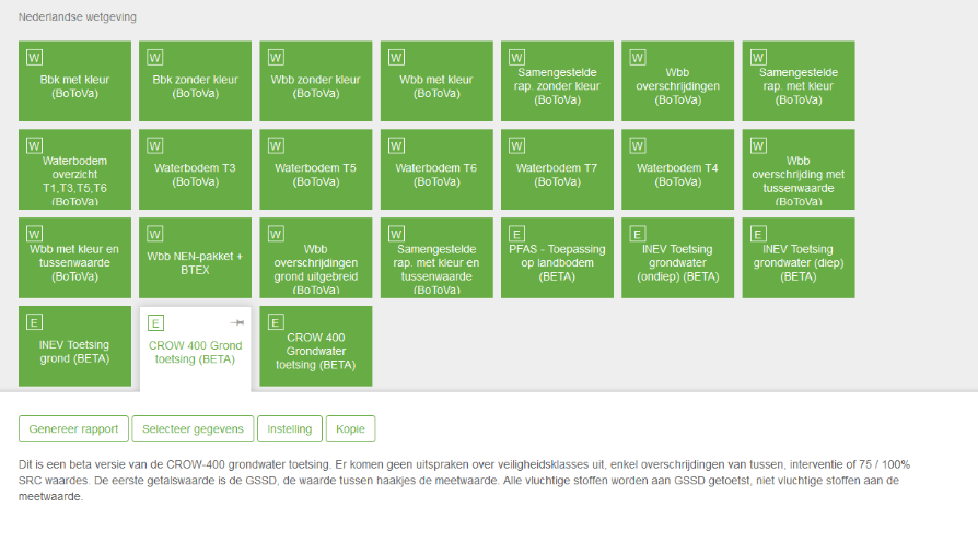
- CROW 400 under the Dutch assessments has been adjusted to the new legislation and made available for all users.
- ESR Report for Walloon users has been made available in the French language. This report prints all measured analysis results that appear in the ESR assessment next to each other, so they can easily the imported in the official ESR excel macro.
Extra information
KLIP
KLIP is the ducts and cable format used in Belgium and can now be imported and synchronised within Terraindex. After uploading your KLIP file you will be able to turn specific cables on / off in the map functionality just like KLIC files. For the layout and colours of the KLIP files the documentation of the KLIP viewer from the Belgium government is used.
How does it work in web?
- Upload the KLIP file. This can be done by klicking the 'add a new maplayer' on the project overview. (Note: This can take a while)
- When the upload is done, a new block will appear in the maplayers column. Under the KLIC documents column all supplemental documents in the KLIP will be added. (We will rename this column in the future)
- When you navigate to the map in Terraindex a new maplayer will be availlable in this project bearing the name of the KLIP file.
- If you make this maplayer visible by cliking on the eye icon, your KLIC information can be seen on the map.
How does it work in the App?
- Ensure that the projectleader has added the KLIP documents beforehand in the office.
- Synchronise the project.
- In the project details screen you can now see the KLIP documents in the column named 'KLIC files'. (We will rename this column in the future)
- If you navigate to the map, you will be able to see the KLIP information if you make the maplayer visible.
NOTE: KLIP Documents will only be availlable if you are working online with the app. The klip maplayer will always be availlable once it's synchronise, even if you have no internet connection.
MarXact
In the windows app it is now possible to connect directly with your MarXact GPS. You will no longer need to fiddle with external tools like our GPStoHTTP but can choose directly which GPS you want to use. As of now, MarXact is not yet sending the HDOP, PDOP and VDOP values to the app. The iOS build will soon follow.
CROW 400 Assessment
It was returned! Because of the new rules for CROW400 assessments we had to take this report offline at the start of 2023 since it was no longer correct. We have now made the correct adjustments to this assessments and made it available for all users again. All volatile components will be assessed against the GSSD values, while all non-volatile components will be assessed against the measurement values. Another change is that in the report now both GSSD and measurement values will be shown, if available.