Soil research BRL 2001 / 2002
Introduction
This memo is about the work process of fieldworkers that perform soil research in compliance with the BRL 2001/2002 in the field and register their data into TerraIndex.
This document describes the processes mentioned in the flowcharts related to the BRL SIKB 2001 and 2002 processes. Below is a legend of the symbols used in the process flowcharts.
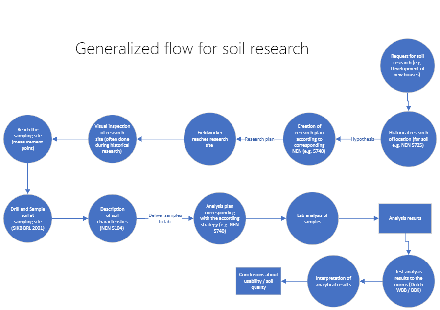
- Page BreakBasic process for soil research
This flow, in very basic steps, describes the process of doing soil research, for example using the NEN 5740, although the protocol is also used in asbestos in soil research (NEN 5707). This flow is there to give a basic idea of the processes in soil research and where the BRL SIKB 2001/2002 fits into it. The BRL SIBK 2001/2002 mainly concerns the fieldwork portion of soil research.
Workflow of the BRL SIKB protocol 2001 in the field
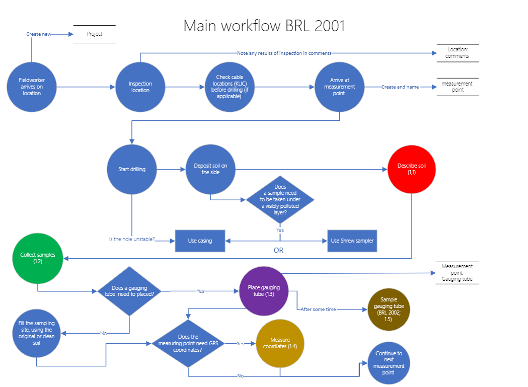
The main process flow gives a basic overview of a typical sampling process in which the BRL2001 is used. The protocol typically starts after the fieldworker has reached the sampling site. The fieldwork starts with an inspection of the research location. This includes crosschecking the location of the measurement points with the location of cables obtained from KLIC.
Afterwards the fieldworker starts drilling at the measurement points, while depositing the soil from the site on a clean sail or plastic layer. Once done, the soil needs to be described, and samples need to be taken. Both of these processes are discussed in more detail in later flowcharts.
The BRL SIKB 2001 also describes the placement of monitoring wells and the measuring of GPS coordinates. Both of these processes are shortly expanded upon in a later flowchart.
1.1 Describing Soil
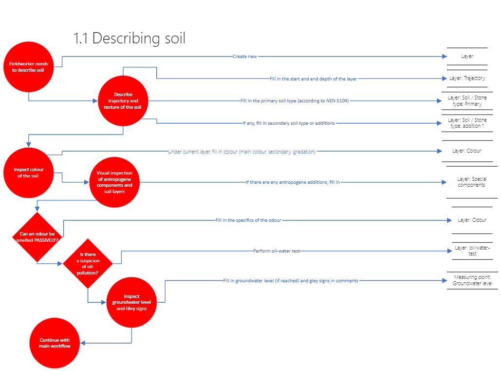
After the measurement point has been made and the drilled and the soil needs to be described, this process starts. It's important to note that in Terraindex, all these steps take place within the domain of the 'measurement point', and most of these characteristics are described within a 'layer' of said measurement point. An overview of terraindex fields that can be filled in in this section can be found at "2.0 Fields that can be filled in in terraindex".
The measuring point that's been dug up can be divided into one or more layers of soil, depending on the type of soil, additions or mixtures in the soil or length of the trajectory. Each layer will get described the following characteristics:
Trajectory
The trajectory denotes the beginning and end of the layer, for example 0cm till 50cm-gl.
Texture
The texture divides the soil into several categories described in the NEN 5104. These are clay, sand, pebble, loam, peat, along with a denotation of the coarseness of the material (in case of mineral soil) or secondary components.
Colour
Colour is often used to make an estimate of the organic content in the soil. Colour can help classify the soil type in some cases and the presence of certain compounds such as iron.
Visual inspection of anthropogenic elements in the soil
There are various anthropogenic elements which can appear in soil, ceramic shards, glass, plastic, coals etc. These are inspected and noted down here, as they can possibly be a source of pollutants.
Odour
If a soil has a distinct odour this can be an indication of a pollutant present. This field is not always applicable.
Oil-water reaction test
If there is a suspicion of oil pollution in the sample (for example because of previous research or smell), the oil-water test can be performed to determine if there is strong oil pollution present. This is done by adding water to a bit of the soil in a container, and seeing the (hydrophobic) layer of oil float up.
Groundwater level and gley signs
The groundwater level is the depth at which the earth is saturated with water. This is a momentary measurement, as the groundwater level can change depending on some factors (such as rainfall). Gley signs are indications that the groundwater level changes, usually seen as 'rust spots' in the soil. Iron in the soil exposed to water oxidizes and turns to rust, which can be visible in the soil in some cases.
1.2 Taking samples

Samples have to be representative of the soil layer they're originated from. As the nature of the layers will affect the composition of mixed samples it's important to take representative samples and the properly split the samples into the appropriate layers are described in the previous step.
If there's a suspicion of pollution with volatile pollutants, a normal measuring jar will allow the majority of the pollutants to dissipate before the sample has reached the lab for analysis. For this reason, socket samples are taken, which have an airtight sealing to preserve as much of the original state of the sample as possible.
Samples should be kept at appropriate conditions and cooling until delivered to the lab. Samples are delivered to the lab preferably within 24-48 hours after sampling.
1.3 Gauging tube placement
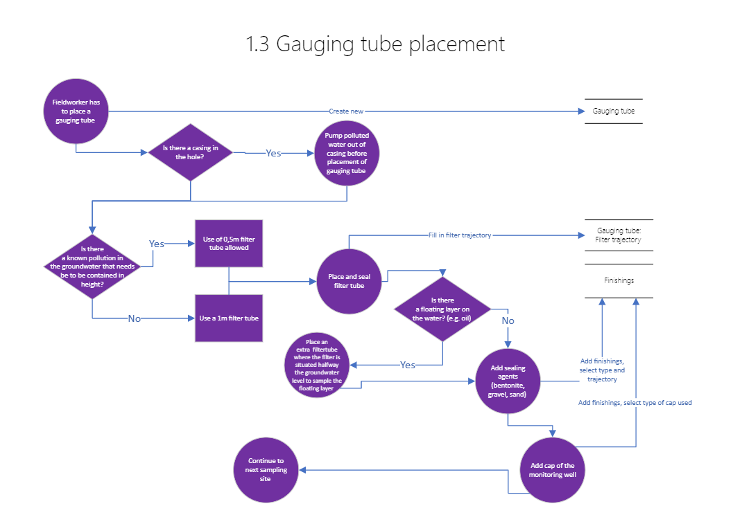
Monitoring wells are used to take a groundwater sample by placing a filter tube of which groundwater can then be collected at a later date.
If there's a casing present in the hole (because of a clearly polluted layer for example), water in the hole must be pumped out before placing the monitoring well, otherwise the groundwater will be contaminated by the polluted layer and does not give a representative view of the pollutants present in the groundwater.
If there's a floating layer on the groundwater (e.g. oil floating), an extra filter tube has to be placed beside the standard filter to sample the floating layer of water. This is done by placing the filter halfway the groundwater level. By placing the filter halfway through the groundwater level instead of below, it ensures that water from the floating layer gets sampled as well.
1.4 Measuring coordinates
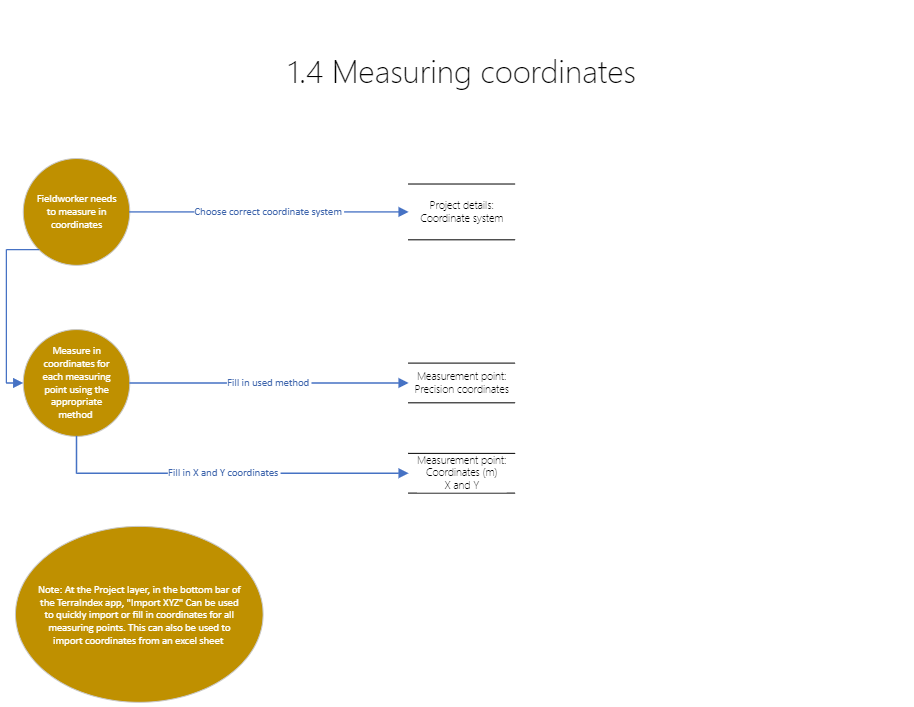
For certain projects the exact location of the measurement points is very important, and the coordinates need to be measured in. The accuracy of the measurement depends on the method used. Certain research strategies in the Dutch NEN require a more accurate measurement so that pollutants can be contained accurately enough; the allowed measurement methods for further research are described within there. This flow mostly describes the process of filling in the measurements in Terraindex, which can either be done at every individual measurement point or in bulk through the "import x and y" table function.
1.5 BRL 2002 – Monitoring well sampling
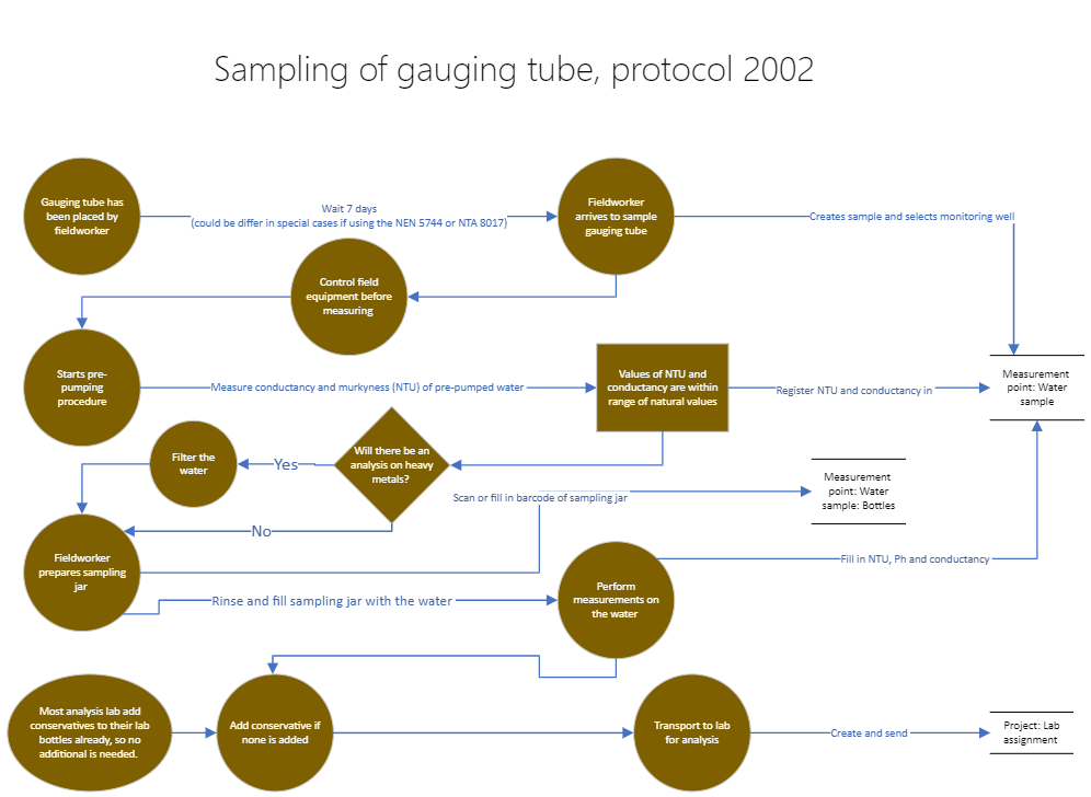
This flow describes the process of sampling the gauging tube, if placed during the fieldwork earlier in the SIKB BRL 2001. It's important that the fieldworker checks if the measuring equipment is working correctly before moving out and that the sampling containers are clean and not past their expiration date. Many labs already add conservatives for groundwater to their bottles, which is why the expiration date is important. Also note that conservatives often do not have to be added manually anymore, although this step is still included in the protocol 2002. The barcode of a bottle of the lab usually relates back to a specific type of sampling bottle with the correct conservation added. For more details it is recommended to contact your analysis lab.
When analysing heavy metals, it's important that the water is filtered properly before sampling. This is not needed if heavy metals are not being analysed, though since heavy metals are a part of the standard package for groundwater analysis most water samples will get filtered.
Some of the specific guidelines in the sampling process differ slightly when using the NEN 5744 or NTA 8017 to sample the monitoring wells.
2.0 Fields that need to be filled in TerraIndex according to the BRL
------------------------------------------------------------------------------------------------------------------------
Below is a table with mandatory and optional fields for soil research and the location of those fields in terraindex. It has to be noted that a lot of the ‘optional’ fields to have to be filled in if applicable (For example, if a monitoring well is placed, filling in the groundwater level is not optional).
Attribuutnaam | Veldomschrijving | Verplicht | Optioneel | TerraIndex |
|
|
|
|
|
Project |
|
|
| Projectdetails |
Projectidentificatie | Projectcode | x |
| Projectcode |
Opmerking | Opmerking |
| x | Opmerking |
Bureaus | Veldwerkbureau(s) |
| x | Veldwerkbureau |
meetpunt |
|
|
| Meetpuntdetails |
Boringnummer | Boornummer of -code | x |
| Meetpunt |
Boortype | Type boor | x |
| Type |
Datum veldwerk | Datum uitvoering veldwerk | x |
| Datum |
- | Maaiveldtype |
| x | Maaiveldtype |
Maaiveldhoogte | Hoogte van het maaiveld |
| x | Maaiveldhoogte |
Referentievlak | Rreferentievlak maaiveld |
| x | Referentievlak |
Boordiepte | Diepte t.o.v. referentievlak | x |
| Diepte |
Grondwaterstand | Gws |
| x | GWS |
Coordinaten | x | x |
| Coordinaten |
Coordinaten | y | x |
| Coordinaten |
Veldwerker | Boormeester |
| x | Boormeester |
Monsternemer | Monsternemer |
| x |
|
Afwijkingen | Opmerking/omschrijving |
| x | Opmerking |
Lagen |
|
|
| Laagdetails |
Bodemlaag | Van | x |
| Traject |
Bodemlaag | Tot | x |
| Traject |
Textuur | Grondsoort |
| x | Grond / steensoort |
PID-meter | PID-meter |
| x | PID |
Boorsystemen | Boorsysteem | x |
| Boorsysteem |
Diameter | Diameter boorsysteem |
| x |
|
Olie-water-proef | Olie-water-proef |
| x | Olie/water-reactie |
Kleur | Hoofdkleur | x |
| Kleur |
- | Bijkleur |
| x | KLeur |
- | Kleursterkte |
| x | Kleur |
- | Opmerking |
| x | Opmerkingen |
Geur | Geur (passief waargenomen) |
| x | Geur |
- | Geurintensiteit (passief waargenomen) |
| x | Geur |
Antropogene kenmerken | Bijzonderheid-type |
| x | Bijz. best. Delen |
- | Bijzonderheid-gradatie |
| x | Consistentie |
- | Bijzonderheid-oorsprong |
| x | Opmerkingen |
- |
|
|
|
|
- | Bijzonderheid-opmerking |
| x | Opmerkingen |
Veldmonster |
|
|
| Veldmonster details |
Boring- en monstercode | Naam/code van het monster | x |
| Naam |
Diepte tov grondopp | Van | x |
| Traject |
Diepte tov grondopp | Tot | x |
| Traject |
Monstercodering | Barcode |
| x | Barcode |
- | Verpakking |
| x | - |
Datum | Datum |
| x | Datum |
- | Tijd |
| x | Datum |
PID-meter | PID-meter |
| x | pid |
Monsternemer | Monsternemer |
| x | Monsternemer |
Opmerking | Opmerking |
| x | Opmerking |
Methode | Geroerd/ongeroerd monster/steekbus | x |
| Geroerd |
Peilbuis |
|
|
| Peilbuis details |
Peilbuisnummer | Naam/nummer | x |
| Peilbuis |
Diepte tov mv | Van | x |
| Filtertraject |
Diepte tov mv | Tot | x |
| Filtertraject |
Traject filtergrind | Grind-van | x |
| Afwerking details.Traject |
Traject filtergrind | Grind-tot | x |
| Afwerking details.Traject |
Traject bentoniet | Bentoniet-van | x |
| Afwerking details.Traject |
Traject bentoniet | Bentoniet-tot | x |
| Afwerking details.Traject |
Materiaal peilbuis | Materiaal |
| x | Materiaal |
Grondwatertoestroming | Doorloop/toestroming |
| x | Doorloop |
Werkwater | Werkwater | x |
| Werkwater |
EC | Ec (bij plaatsing) |
| x | Ec bij plaatsing |
pH | pH (bij plaatsing) |
| x | pH bij plaatsing |
Peilbuishoogten | Hoogte buis tov maaiveld of referentievlak |
| x | BOPB |
Diameter peilbuis binnenzijde | Diameter binnen |
| x | Binnendiam |
Opmerking | Opmerking |
| x | Opmerking |
Gespoeld | Gespoeld |
| x | Gespoeld |
Leegezogen | Leegezogen |
|
| L. gezogen |
Filterkous | Filterkous |
| x | Filterkous |
Grondwaterstand | Grondwaterstand tov referentievlak | x |
| GWS (cm-ref) |
Afwerking peilbuis |
|
|
| Afwerking details |
Afwerking | Afwerking |
| x | Type |
OPmerking | Opmerking |
| x | Opmerking |
Casing |
|
|
| Afwerking details type.Casing |
Diepte tov mv | Van |
| x | Afwerking details.Traject |
Diepte tov mv | Tot |
| x | Afwerking details.Traject |
Opmerking | Opmerking |
| x | Opmerking |
Watermonster |
|
|
| Watermonster |
Boring-monstercode | Naam/code van het monster | x |
| Watermonster |
Datum | Datum | x |
| Datum |
- | Tijd |
| x | - |
Grondwaterstand | GWS tov referentievlak |
| x | Ref. vlak GWS |
Referentievlak | Referentievlak |
| x | Meetpuntdetails.Referentievlak |
Boor- en monsternemingstoestel | Monstername apparaat | x |
| Pomp monstername |
Troebelheid | Troebelheid | x |
| Troebelheid monster |
- | Debiet |
| x | Afpompdeb. Monstername |
- | Belucht | x |
| Belucht |
Kleur | Hoofdkleur |
| x | Kleur |
Geur | Geur |
| x | Geur |
EVG | EVG | x |
| Ec |
pH | PH | x |
| pH |
Temperatuur | Temperatuur |
| x | Temperatuur |
Zuurstof | Zuurstof | x |
| Zuurstof |
- | Redox |
|
| Eh/redox |
Drijflaag | Drijflaag |
| x | Drijflaag |
Zaklaag | Zaklaag |
| x | Zinklaag |
Monsternemer | Monsternemer | x |
| Monsternemer |
Voorpompen | Voorpompen |
| x | Voorpompen |
Geconstateerde afwijkingen | Opmerking/afwijkingen | x |
| Opmerking |
|
|
|
| Flesdetails |
Monstercode | Barcode | x |
| Barcode |
Filtreren | Gefilterd | x |
| Gefilterd |