ISO 14688 Fieldwork process
Geotechnical investigation and testing- fieldworkers process
Date: 28-01-2021
Writer: Extern / Roelof Zwaan
This memo is about the workprocess of fieldworkers that perform Geotechnical investigation in the field and register their data into TerraIndex.
This document describes the processes mentioned in the flowcharts related to the ISO 14688 processes. Each circle represents a process, every term between lines represents an output, usually in the form of something that can be filled in in terraindex.
Basic process for Geotechnical soil research
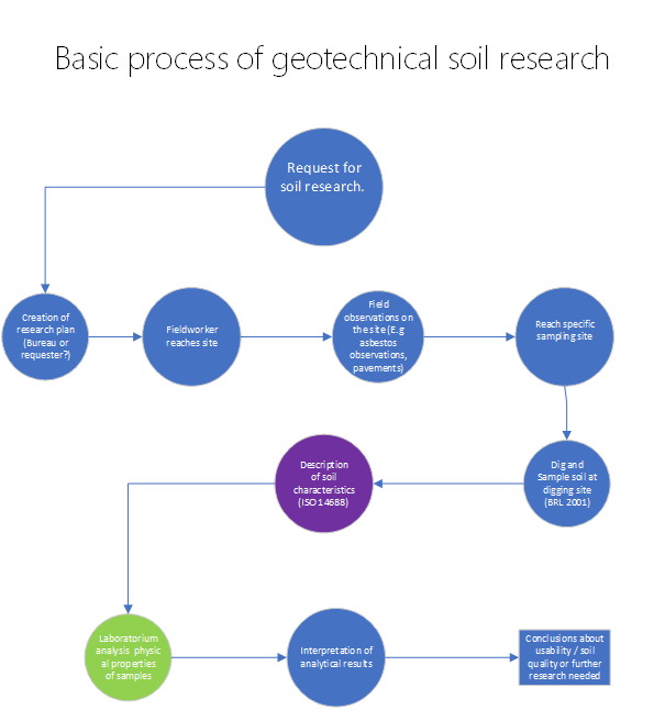
This flow, in very basic steps, describes the process of doing geotechnical soil research. This flow is there to give a basic idea of the processes in soil research and where the ISO 14688 fits into it.
Geotechnical drilling and describing soil in ISO14688 in the field
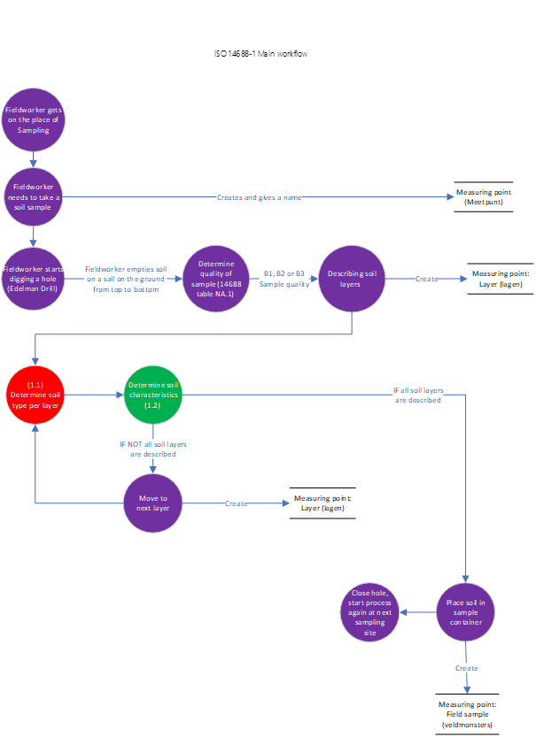
The main process flow gives a basic overview of a typical sampling process in which the ISO 14688 is used.
The ISO 14688 is a European standard used to describe soil when doing geotechnical soil research. The protocol typically starts after the hole was been made and the soil needs to be described. This means after the 'Fieldworker starts drilling a hole' process bulb on the Main process flow.
The first step is the determination of the quality of the sample. The description process of soil in the Dutch norm depends on the 'Description quality class' (Table NA.1 ISO 14688), in which three classes are defined: B1, B2 and B3. B1 is the most detailed and B3 is the most basic. This class determines which characteristics of the soil are described or not.
In flow 1.2, above certain processes it'll say [B1 or B2]. This means that this process is only for description quality B1 / B2 and NOT for B3.
In Terraindex, the soil will be described inside the "Layer" tab of the measuring point. For each layer, the soil type needs to be described and the soil characteristics. These variables each have their own Tab layers (1.1 and 1.2 respectively) which describe these processes in more detail.
After the description, the ISO14688 protocol does not contain any information about other aspects of soil research.
Describing Soil layers
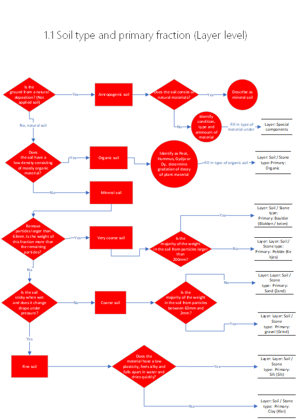
The field worker usually digs until the intended depth is reached, laying all the soil out in one long strip on a sail, giving a visual presentation of the soil profile on a horizontal plane.
The soil then gets split into different layers depending on several factors: The type of soil, mixture of secondary components (rocks, shells etc) in the soil, or depth (usually every 100 cm if there's no change in soil type etc).
There's a distinction made between various different soil types in the ISO 14688. Although most of them are described using similar parameters and characteristics, some specific soil types have specific tests associated with them. The soil types will also be mentioned in the characteristics tab, 1.2.
A short overview of different soil types mentioned in the ISO 14688
Mineral Soil
Mineral soil is used to describe soils with mostly silica and mineral type compounds and low organic content. The main process to describe soil is based on the mineral soil process. The most important parameters in describing minerals are:
-The size (range), shape of the grains in the soil
-The fraction of different sized grains in the soil
-Plasticity of the soil (consistency)
-Organic material present in the soil
Within Mineral soil, depending on the size of the grains there are, from large to small, the following subtypes: boulder, pebble, gravel, sand, clay and silt.
Organic Soil
Organic soil is soil constisting of mostly organic content and low density. Organic soil is subdivided into several other categories.
-Peat
Not fully decayed plant material in acidic, anaerobic conditions. In addition to noting down "Peat" as the organic soil type, the fieldworker also has to make an indication as to how much the plant material in the peat soil has decayed.
-Compost/ Humus
Organic soil matter decomposed by a mixture of anaearobic organisms. Much more fully decayed than Peat.
-Gyttja
Black, mud-like substance that is formed by the further decay of Peat in anaerobic conditions
-Dy
Dy is formed by acidic water with high soluable organic content. Similar to Gyttja but nutrient poor.
-Detritus
Dead organic material, or organic waste material, either dissolved in water or mixed through soil
-Lignite
Compressed peat, more decomposed.
Other than those specific characteristics, if there's any mineral mixture the parameters from the mineral soil are also applied and described for organic soil.
Limestone soil
Soil with a high content of calciumcarbonate, mostly near coastal areas as it's often caused by marine deposition. This soil is decribed as Organic soil, but with the addition of an acidity test to determine the calciumcarbonate content in the soil.
Sulfur-rich soil
Darkly coloured soil with a distinct smell and usually low organic content. Many of the parameters used to describe mineral soil are not easily applicable here.
Volcanic soil
Soil with a large content of volcanic material, often with a glass-like structure. Described as mineral soil- Density can be significantly lower with volcanic soil.
Löss
Very light and small-grain sized deposition of 90% silt with sand and/or clay. Low density. Described as mineral soil
Glacial soil
Deposition of soil from the ice ages. Can vary heavily in organic content and grain sizes. Described like mineral soil.
Antropogenic / applied soil
Applied soil, often brought in for construction work (like a sand layer or soil depots spread over an area). Described as mineral soil. Can contain non-natural materials. Description in B1 quality should contain:
-Origin of the material
-Large fragments
-are there hollows / hollow objects that could collapse?
-Is there chemical waste or dangerous compounds?
-Is there organical material? How much decay is there?
-Any particular smell?
-Colour
-Structure, variability and movement
-Paper trail of the soil if availlable
-Drawing underground heat sources if on location ![]()
Most soils are described as mineral soil, with the exception of organic soil. - Although if organic soil has a secondary mineral fraction, that fraction will be described according to the mineral soil protocol.
Some soils require additional tests such as the acid test for limestone soils to determine the calciumcarbonate content. This will be mentioned in the characteristics tab (1.2)
Soil Characteristics
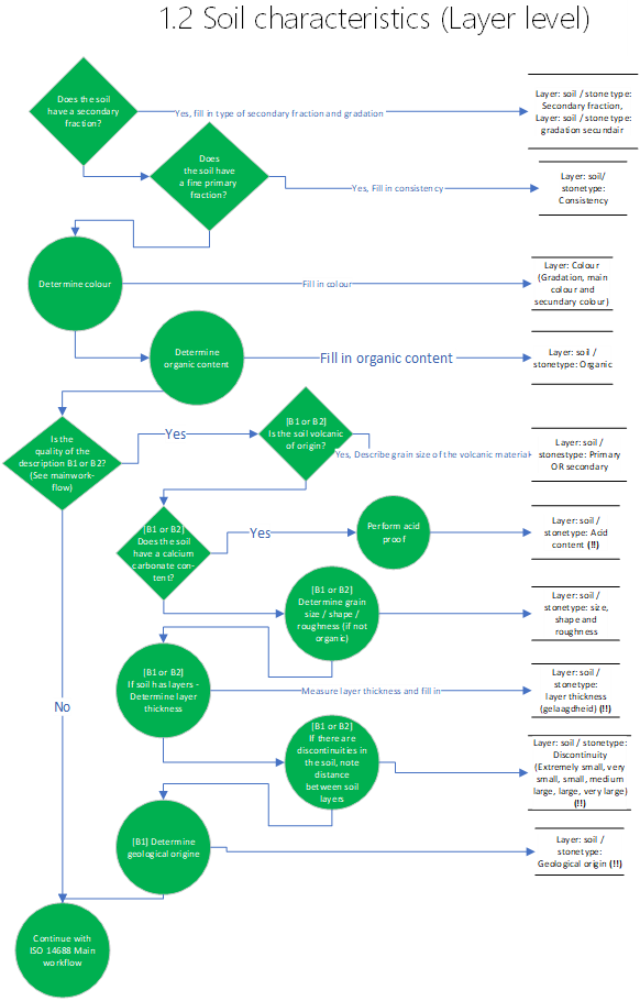
Below the terms used in the soil characteristics flow are shortly described.
Fractions
Fractions refers to the average size of the particles in the soil and their relative abundance in the soil. E.g., 80% of the soil consists of Sand (<63µm --- >2µm), but there's a small portion of clay (Particles smaller than 2 µm). The secondary fraction is usually used as a description of the primary fraction, e.g., Clayey Sand. Tertiary fractions are only described if it's important to the origin of the soil.
Consistency
Consistency refers to the structural cohesion of the invidual grains in the soil. In practice this means the resistance of the material to deformation, e.g., how quickly the soil cracks or breaks apart when pressured.
Colour
Colour is often used to make an estimate of the organic content in the soil. Colour can help classify the soil type in some cases and the presence of certain compounds such as iron.
Organic content
Organic content can be, as previously mentioned, estimated based on the colour and the presence organic compounds in the sample, such as leaves and twigs.
Acid tests
Acid tests are used to determine the level of calciumcarbonate in the soil. The acid (usually hydrochloric acid) reacts with the calciumcarbonate in the soil, the stronger the reaction the higher the calcium content is.
Volanic material
If there is volcanic material present in the soil, the grain size of the volcanic components needs to be described. This is similar to regular mineral soil, except that the distinction of volcanic origin is made and different nomenclature is used.
Plasticity
Plasticity relates to consistency but is tested differently and only with fine fractions of wet soils. The field test consists of rolling the soil in a thin strip and rating plasticity based on wether or not a wire can be formed with the soil.
Grain size / shape / roughness
For detailed descriptions of mineral soils, the grain size / shape and roughness need to be determined in the field if possible.
Layer thickness [B1 / B2]
Not to be confused with the description of soil in layers. Sometimes soil consists of many small geological layers. If present, the thickness of the layers must be noted down.
Discontinuities [B1 / B2]
Discontinuities refer to a break in the geological formation or a sudden change in the grain size / fraction distribution of the soil. If they are present, they should be noted.
Geological origin [B1]
If possible, the geological original of the deposition can be traced and noted down.
ISO 14688-2 Laboratorium tests for soil characteristics
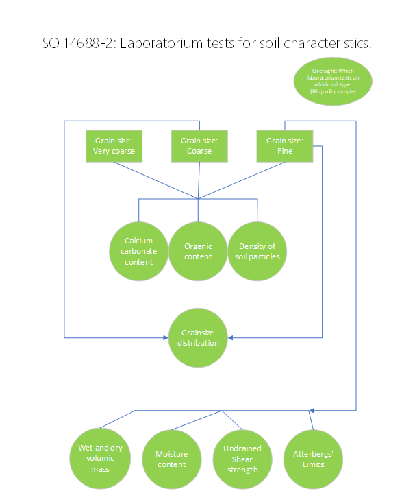
For very detailed analysis of soil characteristics, certain lab tests can be used. The ISO makes a recommendation which test to use on which type of soil.
Fields that need to be filled in TerraIndex: (More complete file here:
| ISO14688 | Minimale monsterklasse | Opmerkingen | (Enkel noodzakelijke velden opgenomen) | ||||
| Kenmerk | |||||||
| Bepaling bijzonder materiaal | QM5 | Veldwerk (Eventueel met aanvulling lab | |||||
| Bepaling bijzondere bestandsdelen | QM5 | Lab | |||||
| Bepaling antropogeen of natuurlijke grond | QM4 | Niet invullen / vervallen voor deze beschrijfkwaliteit | |||||
| Organische grond | |||||||
| Bepaling primaire fractie | QM4 | ||||||
| Bepaling secundaire fractie | QM4 | ||||||
| Veentextuur | QM4 | ||||||
| Gelaagdheid | QM2 | ||||||
| Laaggrensbepaling | QM5 | ||||||
| Kleur | QM5 | ||||||
| Geur | QM5 | ||||||
| Veenconsistentie | QM3 | ||||||
| Discontinuiteiten | QM3 | ||||||
| Broekjes (geroerd) | QM5 | ||||||
| Disperse inhomogeniteit | QM3 | ||||||
| Treksterkte vezels | QM3 | ||||||
| Geologische herkomst | QM3 | Niet noodzakelijk voor B2, B3 | |||||
| Extra aspecten veeclassificatie | Optioneel veld | ||||||
| Grove grond | |||||||
| Bepaling primaire fractie | QM5 | ||||||
| Bepaling secundaire fractie | QM5 | ||||||
| Tertiaire fracties | QM5 | ||||||
| Mediane korrelfractie | QM5 | ||||||
| Verbijzondering mediane korrelfractie | QM4 | ||||||
| Korrelhoekigheid | QM5 | ||||||
| Kleur | QM5 | ||||||
| Gehalte organisch stof | QM4 | ||||||
| Kalkgehalte | QM5 | ||||||
| gelaagdheid | QM4 | ||||||
| Laaggrensbepaling | QM5 | ||||||
| Discontinuiteiten | QM3 | ||||||
| Brokjes (geroerd) | QM5 | ||||||
| Disperse inhomogeniteit | QM3 | ||||||
| Geologische herkomst | QM3 | Niet noodzakelijk voor B2, B3 | |||||
| Zeer grove grond | |||||||
| Bepaling primaire fractie | QM5 | ||||||
| Bepaling secundaire fractie | QM5 | ||||||
| Tertiaire fracties | QM5 | ||||||
| Korrelruwheid | QM5 | ||||||
| Korrelhoekigheid | QM5 | ||||||
| Kleur | QM5 | ||||||
| Aandeel organisch materiaal | QM5 | ||||||
| Laaggrensbepaling | QM5 | ||||||
| Brokjes (geroerd) | QM5 | ||||||
| Geologische herkomst | QM3 | Niet noodzakelijk voor B2, B3 | |||||
| Fijne grond | |||||||
| Bepaling primaire fractie | QM5 | ||||||
| Bepaling secundaire fractie | QM5 | ||||||
| Tertiaire fracties | QM5 | ||||||
| gelaagdheid | QM4 | ||||||
| Laaggrensbepaling | QM5 | ||||||
| Kleur | QM5 | ||||||
| Aandeel organisch materiaal | QM5 | ||||||
| Consistentie | QM4 | ||||||
| Kalkgehalte | QM4 | ||||||
| Discontinuiteiten | QM3 | ||||||
| Brokjes (geroerd) | QM5 | ||||||
| Disperse inhomogeniteit | QM3 | ||||||
| Geologische herkomst | QM3 | Niet noodzakelijk voor B2, B3 |